Purva Attibele Location

Purva Attibele sits at Attibele Hobli in Anekal Taluk, near Attibele on the NH-44 (Hosur Road) corridor at the southern edge of Bengaluru, pin code 562107. The address places it between two distinct economies — Electronic City's technology cluster to the north and the Hosur manufacturing grid ten kilometres south across the Tamil Nadu border — with the Attibele, Bommasandra and Jigani industrial areas in between. This page covers the corridor logic, road and metro connectivity, the employment geography, social infrastructure, and the honest trade-offs of buying at Bengaluru's southern boundary.

Macro Position — Bengaluru's Southern Threshold

Hosur Road is one of the few Bengaluru corridors where the employment base does not stop at the city limit. Running south from Silk Board, it passes Electronic City — Infosys, Wipro, Biocon, TCS, HCL and one of India's largest IT clusters — then Bommasandra and Jigani's industrial estates, then Attibele at the NH-44 intersection, and then crosses into Tamil Nadu at Hosur.

Buyers shortlisting Purva Attibele often compare it with Purva Park Royale, a Vakil Garden City project by the same developer that offers a useful reference on format, pricing and delivery record.

Hosur is not a suburb. It is a manufacturing city in its own right, built on TVS, Ashok Leyland, Titan and Caterpillar, with a fast-growing electronics and EV component cluster. It has its own labour market, its own housing demand and its own growth trajectory — and it sits ten kilometres from Attibele.

That dual-economy position is the location's structural argument. A residential corridor tied to a single industry inherits that industry's hiring cycle. When IT services slow, purely IT-dependent Bengaluru micro-markets slow with them. Attibele draws buyers and tenants from IT services to the north and manufacturing to the south, in two states, on different cycles. It is a materially more diversified demand base than most Bengaluru peripheral markets carry.

Micro Position — Why Attibele Hobli

On the name. A hobli is a revenue sub-division within a taluk in Karnataka's administrative structure. Attibele Hobli sits inside Anekal Taluk in the Bengaluru Urban district. It is the precise regulatory phrasing Puravankara used in its own December 2025 disclosure of the 53.5-acre land acquisition, and it is the correct way to describe the project's location in a legal or approvals context.

The pricing position. Attibele apartments average ₹6,450 per sq ft with a range of ₹5,250–₹7,800. Electronic City averages ₹7,400, spanning ₹5,450 to ₹10,250. Attibele is the corridor's affordability anchor — meaningfully cheaper than Electronic City for a location that is 12 to 15 km away from it.

The supply gap. What Attibele has almost none of is branded high-rise product. The existing stock is mid-rise and largely locally developed. There is no flagship podium township from a national listed developer anywhere on this stretch. Purva Attibele's fourteen towers to 80 metres would be the tallest and largest branded residential development on the road by a wide margin.

The infrastructure trigger. Namma Metro's Yellow Line is operational to Bommasandra, connecting the Electronic City belt to the network for the first time. A further Hosur Road extension with a proposed station at Attibele would put the corridor directly on the map.

Road Connectivity

RouteDetail
NH-44 / Hosur RoadThe corridor's primary spine. Attibele sits at the NH-44 intersection, roughly 2 km from the project. Runs north to Electronic City, Silk Board and the city; south to Hosur and onward to Krishnagiri and Salem.
Bangalore Elevated Tollway (BETL)The elevated expressway between Koramangala and Electronic City. It bypasses the Silk Board bottleneck entirely, which is the single biggest determinant of a Hosur Road commute time into central Bengaluru.
Attibele–Sarjapur RoadThe east-west link from Attibele to Sarjapur, and onward to the Sarjapur Road corridor and Whitefield. Opens up the eastern employment belt from a southern address.
NICE RoadPeripheral ring linking Hosur Road to Bannerghatta Road, Kanakapura Road, Mysore Road and Tumkur Road without entering the city. Interchange approximately 14 km.
Outer Ring RoadReached via Hosur Road at Silk Board, connecting to the Bellandur, Marathahalli and HSR employment nodes.
Anekal RoadLocal link west to Anekal town and the Jigani industrial belt.

On the Silk Board question. Any honest assessment of a Hosur Road address has to address Silk Board Junction, historically one of Bengaluru's worst traffic bottlenecks. The Bangalore Elevated Tollway is the answer for most journeys — it carries traffic from Electronic City over the congested stretch. For an Attibele resident travelling to central Bengaluru, the elevated expressway is the route that makes the commute viable.

Metro Connectivity

Line / projectStatusRelevance
Yellow Line — Bommasandra terminusOperationalApproximately 10 km from the project. Connects the Electronic City belt to the Namma Metro network for the first time, running north via Electronic City, Hosa Road, HSR Layout and Jayadeva to Silk Board and RV Road.
Yellow Line — Electronic City stationsOperationalDirect metro access to the Electronic City campuses from the corridor.
Proposed Hosur Road extensionProposedA metro extension along Hosur Road with a proposed station at Attibele would put the corridor directly on the network. Proposed, not funded and under construction.

The Yellow Line reaching Bommasandra is the most consequential recent infrastructure event on this corridor. It changes the Electronic City commute from a road-only proposition to a rail one, and it establishes the precedent for extending further south. A resident today drives to Bommasandra and boards; a resident after an Attibele extension would board locally.

Underwrite the purchase on what exists — the operational Yellow Line at Bommasandra and the elevated expressway. Treat the Attibele station as an option with real value if exercised.
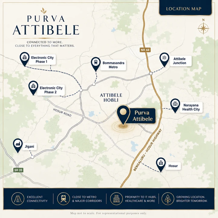
Purva Attibele location map showing connectivity from Attibele Hobli to Electronic City Phase 1 and 2, Bommasandra Metro, Attibele Junction, Narayana Health City, Jigani and Hosur
Location Map — Purva Attibele

Rail and Air

  • Anekal Road Railway Station — approximately 12 km. Local halt on the Bengaluru–Hosur–Salem line.
  • Hosur Railway Station — approximately 12 km, across the state border.
  • Carmelaram Railway Station — approximately 20 km via Attibele–Sarjapur Road.
  • KSR Bengaluru City Junction — approximately 35 km via Hosur Road and the elevated expressway.
  • Kempegowda International Airport — approximately 70 km via NICE Road and the ORR. This is the location's principal connectivity weakness; budget two hours.

Employment Hubs

DestinationApproximate distance
Attibele Industrial Area3 km
Bommasandra Industrial Area9 km
Hosur industrial belt (TVS, Ashok Leyland, Titan, Caterpillar)10 km
Electronic City Phase 212 km
Jigani Industrial Area12 km
Electronic City Phase 1 (Infosys, Wipro, Biocon)15 km
Anekal town8 km
Sarjapur (via Attibele–Sarjapur Road)17 km
Bannerghatta Road IT corridor25 km

Nine employment nodes inside 25 km, spanning IT services, biotechnology, automotive manufacturing, electronics and general industry, across two states. The diversity is the point.

Schools

SchoolApproximate distance
MEGA International School, Attibele4 km
National Public School, Anekal8 km
Treamis World School, Electronic City8 km
Sherwood High, Electronic City11 km
Ebenezer International School, Electronic City12 km
VIBGYOR High, Electronic City12 km
Delhi Public School, Electronic City13 km
Indus International School, Sarjapur20 km
Gear Innovative International School22 km

The school cluster is concentrated in Electronic City rather than at Attibele itself — a 20 to 30 minute run for the international options. This is one of the corridor's genuine trade-offs against a more established address.

Hospitals

HospitalApproximate distance
Attibele Government Hospital3 km
Narayana Health City, Bommasandra9 km
Vimalalaya Hospital, Attibele4 km
Sparsh Hospital, Electronic City13 km
Oxford Medical College Hospital14 km
Athreya Hospital, Electronic City14 km
Chaithanya Hospital, Electronic City14 km
Hosur Government Hospital11 km

Narayana Health City at Bommasandra is the standout. It is one of India's largest multi-speciality medical campuses, and at 9 km it is the practical answer for anything serious. Very few Bengaluru peripheral corridors have a tertiary facility of that calibre within ten kilometres.

Want the current Phase 1 information pack, the anticipated cost sheet, or a site visit at Attibele Hobli? Ask the team directly.

Request Project Brief

Retail, Dining and Everyday Convenience

Malls and organised retail. M5 Ecity Mall (Electronic City, ~13 km), Decathlon Electronic City, D-Mart, and Neo Mall — a new development by the Patel Group coming up in Electronic City. Royal Meenakshi Mall on Bannerghatta Road is roughly 25 km.

Attibele high street. Attibele town carries a working retail base — supermarkets, pharmacies, banks, clinics, hardware, restaurants and the daily-needs infrastructure that a town at a highway intersection accumulates. It is functional rather than aspirational, and it is improving as the residential base grows.

Hosur. Ten kilometres south, Hosur carries its own retail, dining and hospitality base serving a large manufacturing workforce — a genuine additional option, though it involves crossing a state border.

The honest position on retail: organised retail is thin at Attibele today and concentrated in Electronic City. This is a corridor where the residential development is running ahead of the lifestyle infrastructure, which is both the reason for the price and the reason for the upside.

The Honest Trade-Offs

It is a genuine periphery. Attibele is the last node before the state border. Central Bengaluru is 35 km away. If your life is anchored in Indiranagar, Koramangala or the CBD, this is a long way out and no amount of infrastructure narrative changes that.

The airport is far. Roughly 70 km and two hours. For frequent international travellers, this is a real and permanent cost.

Social infrastructure is thinner than Electronic City. The international schools, the hospitals with the deepest specialities, and the organised retail are 12 to 15 km north. Attibele's own base is functional but not deep.

The metro is at Bommasandra, not at Attibele. Ten kilometres and a drive. The proposed extension would change this; it is proposed.

Highway-adjacency effects. NH-44 is a national highway carrying heavy freight to Hosur, Krishnagiri and Salem. Proximity to a highway brings connectivity and it brings noise and truck traffic. Ask specifically which towers face the highway side and what acoustic treatment and setback the design provides.

Pre-RERA status. The project has no RERA registration yet, which means no declared completion date and no sanctioned-plan disclosure. This is a project-level rather than a location-level risk, but it compounds the periphery risk for a cautious buyer.

The Investment Case for Attibele

A diversified employment base. Nine employment nodes within 25 km across IT services, biotech, automotive, electronics and industry, spanning two states with different economic cycles. That is unusual resilience for a peripheral Bengaluru corridor.

A structural price gap. ₹6,450 per sq ft at Attibele against ₹7,400 at Electronic City, for locations 12 to 15 km apart on the same highway. Gaps of that size on a single corridor tend to compress as connectivity and branded supply arrive.

Metro momentum. The Yellow Line reaching Bommasandra changes the corridor's character. An Attibele extension would change it again. The direction of travel on this corridor is clearly toward better connectivity, not worse.

Almost no branded supply. Purva Attibele would be the corridor's first flagship high-rise podium township from a national listed developer. First-mover positions in Bengaluru's peripheral corridors have historically delivered both stronger appreciation and better resale liquidity, because the project becomes the address rather than one of several.

Hosur's own growth. Tamil Nadu has been actively developing Hosur as an industrial and electronics hub. Growth there is a demand driver for housing on the Karnataka side of the border, where the schooling, healthcare and social base is deeper — and Attibele is the nearest such node.

Address and Map Reference

FieldValue
AddressAttibele Hobli, Anekal Taluk, near Attibele, South Bengaluru
LocalityAttibele
TalukAnekal
ZoneSouth Bengaluru
Pin code562107
DistrictBengaluru Urban

The precise site coordinates will be published with the project's launch documentation. The address above locates the project within Attibele Hobli on the NH-44 corridor.

Purva Attibele Location — Frequently Asked Questions

Where exactly is Purva Attibele located?

Attibele Hobli, Anekal Taluk, near Attibele, South Bengaluru, pin code 562107 — on the NH-44 (Hosur Road) corridor between the Electronic City technology cluster to the north and the Hosur industrial belt roughly 10 km south across the Tamil Nadu border.

What is Attibele Hobli?

A hobli is a revenue sub-division within a taluk in Karnataka's administrative structure. Attibele Hobli sits inside Anekal Taluk in the Bengaluru Urban district. It is the precise regulatory phrasing Puravankara used in its own December 2025 land-acquisition disclosure.

What configurations are available at Purva Attibele?

Anticipated 1.5, 2 and 3 BHK. Indicative super built-up areas run 950–1,020 sq ft for 1.5 BHK, 1,290–1,400 sq ft for 2 BHK and 1,470–1,640 sq ft for 3 BHK. The project brief describes these as anticipated rather than confirmed; the definitive set is released with the floor plans at launch.

What is a 1.5 BHK and is it worth buying?

A 1.5 BHK is a one-bedroom home with an additional half-room — smaller than a full bedroom and usable as a study, nursery, home office or guest space — that does not carry a second full bedroom's area cost. It suits single professionals, young couples and investors, and it is a configuration with real, persistent search demand in Bengaluru and almost no branded supply answering it. Check whether the half-room has an external window: with one it is a study, without one it is a store.

What is the price of Purva Attibele?

Anticipated pre-launch entry points are from ₹95 lakh for 1.5 BHK, ₹1.30 crore for 2 BHK and ₹1.50 crore for 3 BHK — a working rate band of roughly ₹9,950–₹10,300 per sq ft and an overall range of ₹95 lakh to ₹1.69 crore. Pricing is tentative and not yet official. Budget a further 9–12% for GST, Karnataka stamp duty and registration, club membership, corpus and legal charges.

What is the ₹4,800 crore Attibele Hobli acquisition?

On 23 December 2025 Puravankara announced the acquisition of a 53.5-acre land parcel in Attibele Hobli, Anekal Taluk, with approximately 6.4 million sq ft of saleable development potential and a gross development value exceeding ₹4,800 crore — one of its largest single residential additions in Bengaluru. It took the company's FY26 cumulative land additions to 12.76 million sq ft and roughly ₹13,900 crore of potential GDV. This 28-acre tower enclave is the flagship high-rise component within that wider land bank.